
Ouray, Colorado calls itself the Switzerland of America. Set in a picturesque mountain valley, people have said it looks like a Swiss mountain village. I’ve never been to Switzerland, but if it looks anything like Ouray it is surely worth a visit.

Ouray also calls itself the Jeeping capital of the world. The town was one of the first places to begin offering commercial Jeep tours after Jeeps were made available to civilians. Ouray’s first Jeep tour company opened in 1946 and today the town is full of different companies offering tourists the opportunity to experience the off-road trails of Colorado by Jeep. These trails are mostly on public land and are accessible to anyone with a capable vehicle (be it a Jeep or other 4×4 vehicle). You probably know what’s coming, lots of pictures of Gunner parked somewhere cars were never meant to go.
One of the very cool things about staying in Ouray was the sheer number of Jeeps we saw. Although Jeeps have a huge cult following, we have never been anywhere where Jeeps were the primary mode of transportation. They were everywhere! Walking down Main Street we saw Jeep after Jeep and we were part of the club! Jeepers all wave to the other Jeepers and many are happy to stop and chat with you (about Jeeps, of course). Brandon was in heaven and I immediately regretted not booking a longer stay in Ouray.

We had originally planned to drive straight from Durango to Ouray on Highway 550 North. On a map it looks like a direct shot and the most logical route but while in Durango we learned more about hwy 550 and changed our minds. This road is called the Million Dollar Highway and can be a very dangerous road. It climbs over the mountains with sharp switchbacks and no guard rail. The road was originally built as a toll road during the 1800s to connect the mining towns in the area. When the road was eventually paved, they were still limited by the original construction, making the road rather narrow in places.
The origin of the moniker “Million Dollar Highway” is unclear. It could reference the millions of dollars in gold, silver, and other minerals that were transported using this road over the years. It could also reference how much it cost to build the road or the “million dollar” views. Either way, driving a 37 foot motor home up hwy 550 sounded like a terrible idea. While in Ouray we did see motor homes even larger than ours coming down the mountain from hwy 550 so it must be possible. We never got a chance to ask any of these guys if the views were worth the stress of nearly falling off a cliff with every turn. To each his own. We decided to take the scenic byway (hwy 145 and 62) adding about an hour of drive time and avoiding hwy 550.
The scenic byway is still gorgeous, just not quite as dramatic as hwy 550. It is also still a long climb through mountains. When driving in this area of the country there is really no way to avoid the Rockies. We had to stop a couple of times along the way to let the engine cool down. During one particular stop Brandon accidentally turned off the engine. When already at a high engine temperature the engine can overheat when you turn it off because the coolants stop flowing. When we stepped out of the RV we could see antifreeze overflowing onto the pavement. This meant we would have to hang out for longer than usual so the engine could cool off enough to top up the antifreeze. No permanent damage, just a minor inconvenience, and we just happened to have stopped at a particularly scenic viewpoint. There was a snow melt creek running beside us and snow-capped mountains in the distance. I used the extra time to hike up a nearby hill to snap some photos and take in the view.


When I returned from my hike Brandon told me that he had made a terrible discovery. The rear window on our Jeep was completely shattered. We spent hours racking our brains to figure out how this could have happened. Did a rock hit the tire carrier and bounce back at the window? Did those friendly hikers we passed a while back throw a rock at us? The answer we eventually came to was that the back window hatch had popped open while we were driving because of the weak lower seal. This had happened before but only when we were riding in the Jeep and could pull over to close the window. With the Jeep being towed behind the motor home that window could have been open a long time, just rattling itself to death while we drove up the mountain.
When we finally made it to Ouray we were beat. Us and the rig had survived yet another mountain pass, but not without struggle. We were currently down one Jeep window, in a very small town with no way to source a new window, and there was rain in the forecast.
When we got to our spot at the 4J +1 +1 Campground (no idea why they named it that) we found that our spot was way too narrow. We would never fit. I walked back to the park office and they said we could park further back in the park, in front of the trailer homes. (The park was also home to a mobile home community but it was very well maintained and didn’t appear trashy at all.) We pulled into the new spot in front of the trailer homes, admired the mountains in front of us and reveled in our super wide and level parking spot with no neighbors on either side. We were halfway through our celebratory moving day beers when the park manager walked over to tell us we were in the wrong spot. We were supposed to be three spots down, in a spot that was nowhere near level. It took four tries to level the RV, using every block and board we have, and it still looked like our nose was pointing towards the sky. Ironically, the person who had reserved the wonderfully level spot three doors down didn’t show up until our very last day in Ouray.
Now we were really beat. I almost immediately fell asleep on the couch, totally worn out by all of the many crises.
Brandon woke me up and hour later and I was reminded that I had married the most amazing man. He had opened the blinds next to the couch so that I would wake up and see the mountains out my window. Lavender incense was burning (my favorite) and he very calmly began to tell me how he had solved our broken window problem. He was having a new window shipped to a UPS store in Grand Junction, Colorado (near our next spot) and he even got a good price on the new window. Yep, I picked a good one.
The current crisis solved and needing to redeem the day, we headed into town for appetizers and beer at Ouray Brewery on Main Street. From the 4J RV Park downtown Ouray is only about four blocks away. The park itself is not particularly scenic, the owners have crammed in as many RVs, tents, and trailers as they possibly could, but the view of the mountains is spectacular and the location is unbeatable. In addition to being four blocks from downtown and all of the cute shops and restaurants, you are also within walking distance of numerous hiking trails and a very short drive away from the Million Dollar Highway and a multitude of off-road trails.

When we got to the Ouray Brewery we found the appetizer selection to be minimal but the beer delicious. So appetizers and beer turned into dinner and multiple beers (and a few shots of local whiskey for good measure). All of the beer is brewed in-house.

The food was pretty good too. The place is mostly a BBQ joint but they also serve sandwiches and burgers. I had the smoked salmon filet with dill sauce (awesome!) and Brandon went with the trusty bacon cheese burger.
The rooftop seating area is all communal seating at picnic tables, making it really easy to meet people. We sat with a group of bikers on a long distance road trip of their own. We all had a great time sharing stories of places we had been and where we were headed next.

While the rooftop was a great place to watch the sun set over the mountains, I was a little disappointed we didn’t notice the downstairs bar until we were leaving. They had swings instead of bar stools! Brilliant! Or dangerous, depending on how many of those tasty beers you have.

Back at home we stayed up late having deep conversations about life because, well, whiskey. But hey, we did succeed in redeeming a day that could have been about nothing more than a broken window.

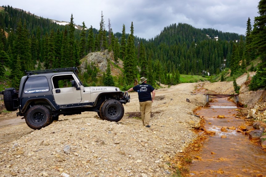
Our big plan for the next day was to take our Jeep out on a real Jeep trail in the Jeeping capital of the world. We packed a lunch, all of our camera equipment, and a bunch of safety equipment that we thankfully didn’t need. In my pack was a first aid kit, camel back full of water, pocket knife, toilet paper, head lamp, walkie talkies, and an off-road GPS. We also had tow straps and lots of other recovery equipment should we get stuck.
Our guidebook had turn-by-turn directions through our chosen trail, the Red Mountain Mining Area. It was supposed to be nine “easy” miles through old abandoned mines and over a ridge at 12,000 feet with a view of the distant snow-capped mountains and the red mineral-rich mountains that drew miners to the area in the first place.
We picked an easy trail because we were alone and didn’t know the area all that well. Back in Oregon we always went out with a group. This would be our first big trail on our own. Even though we were totally prepared, we still got nervous on our way there, wondering if it was smart to go out alone. We just didn’t know what to expect out of the local Jeep trails. We decided to continue on and make a decision once we saw what the trail looked like.
As soon as we turned onto the trail a Nissan Pathfinder followed behind us. Soon we were seeing many stock SUVs, a station wagon, and a couple of cars coming back down the trail. If a station wagon could make it we would be fine.

For the most part the trail really was easy. There were a few tough sections that required higher ground clearance. These sections eventually weeded out all of the cars and stock SUVs. All of the cars we had seen coming back down the trail at the beginning had actually been cars turning around when the trail became too rugged for them. But it was nothing we couldn’t handle.
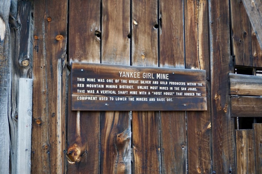
The first half of the trail meandered through forest, over creeks, and climbed up to old abandoned mine shafts.


Reading the turn-by-turn directions in our off-road guidebook took some getting used to. We missed a few turns along the way but eventually found our way.
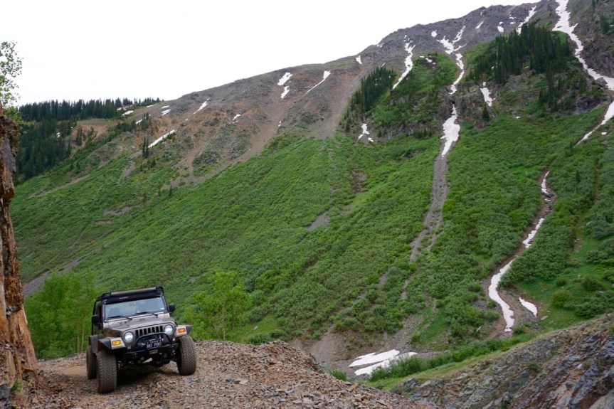
The second half of the trail had us climb up the mountain to a ridge at over 12,000 feet. The air was thin and the view was incredible. We were both nearly speechless. For a few minutes all we said was “wow.” It was also a full 30 degrees colder at this elevation.


The only other vehicle we saw on this section of the trail was a Jeep tour guide with a family in the back.
The route down was much faster. We traversed a wide switch-backed road all the way down the mountain.

All of the buildings up here are falling apart and abandoned but there is a certain beauty to it. There was a small shack behind this particular building that looked like it might still be inhabited. It could be a seasonal hunting cabin or maybe the year-round dwelling of a mountain hermit. We didn’t investigate because whoever lives there probably isn’t too used to people just stumbling upon his house way up in the mountains.

Even at such a high elevation the wildflowers were still blooming. Colorado is just full of wildflowers. They aren’t quite as plentiful as the bluebonnets of Texas but there are far more varieties.

When the trail intersected with hwy 550 we decided to drive south to revisit the town of Silverton. We were only about 15 minutes away and our stop on the train had been very short.
We arrived in Silverton around 3:30 pm, after the last train full of tourists had left for the day. Contrary to what we had overheard on the train, this was actually a very interesting time to visit. There were far fewer people but most of the business were still open. All that were left were the locals and the few tourists staying overnight from the train. It was during this time (right after the train left) that all of the locals came out to enjoy their town, run errands, and have a drink at the local watering hole.
First, we went by a local outdoors store to pick up an extra SD card for the GoPro. We bought the GoPro last Christmas but haven’t posted much video footage because we’ve had nothing but problems with it. For one thing, the file sizes are so huge that we struggle to make enough room on our computer to actually edit the hours of footage we’ve accumulated. But we’ve also had trouble with the camera itself. The camera doesn’t have a screen that shows what you’re filming, but is designed to connect to your phone via wifi so you can view what you’re filming in real-time through the GoPro app. Well, our camera has never been able to connect to wifi so we are always filming blind. We just point the camera in the direction we want and hope it works out. We never know until we get home and upload the footage. We recently learned that our camera is actually defective but is still covered under warranty. We are returning it to GoPro and will receive a brand new one (hopefully soon and hopefully one that works).
After browsing around the outdoors store we stopped by a place called the Rum Bar for snacks and drinks. I had a super spicy bloody mary (just like I like them) and Brandon had a painkiller that rivaled the ones we had in the British Virgin Islands.

For those of you needing a new summer cocktail, painkillers are delish and very easy to make. Make a mix of pineapple and orange juice (equal parts but this is really just to taste, you can’t screw this up) and then add in some coconut milk (a little or a lot depending on how creamy you like your umbrella drinks). Many recipes call for Coco Loco but I prefer canned coconut milk (look in the Asian foods section, it’s the same stuff used for curry). The coconut milk that is sold as a vegan milk substitute (usually near the almond milk) is often too watered down for this application. Now add ice and dark rum to a tall glass (the rum amount is up to your tastes, this mix can handle a lot of rum), top with the pineapple, orange, and coconut mix and stir. Top it all off with a sprinkle of nutmeg. In the islands you can find fresh nutmeg everywhere but pre-ground is fine. Now close your eyes and pretend you’re on a tropical beach. If you actually are on a tropical beach this last step is much easier and we’re all jealous.
The Rum Bar had a tasty but limited tapas menu. Everything was homemade with local ingredients. I had elk empanadas with a mustard horseradish sauce and Brandon had the stromboli. The servings were perfect for a light meal.
Everyone in the bar appeared to know each other. They were also all filthy from the days outdoor adventure but no one seemed to mind. At one point a random dog walked in and ran over to say hi to one of the patrons. He and the dog were clearly old pals. The dog’s owners came trailing behind a minute later and told the man, “She just knew you were here and had to say hello.” It was an adorable small-town moment.
On our way home we drove the famous Million Dollar Highway back to Ouray. It was just as beautiful as advertised and just as narrow and winding. We saw a few motor homes and big rig truckers along the way but I have no regrets about taking the bypass.
On our way home we turned off on a random dirt road that appeared to be a Jeep trail in progress. We saw a parked bulldozer and followed the trail he had been making. The trail didn’t go far but it looks like it’s going to be great once it’s finished.


We only planned for two full days in Ouray, clearly a mistake. There was so much more to do here. It is definitely back on our list if we come back through Colorado.
Our plan for our last full day was to hike the Perimeter Trail. The Perimeter Trail is from four to six miles long, depending on who you ask and which route you take. The trail circles the entire town of Ouray but has many entrance and exit points along the way to either shorten or lengthen your hike. I had ambitions to hike the whole thing.
We got our backpacks packed and drove over to the trail head at the visitors center next to the hot springs. Almost as soon as we pulled into the visitors center it started to rain. There was thunder and lightning and the lifeguards at the hot springs were calling everyone to get out of the pool. We also didn’t have a back window and couldn’t leave the Jeep parked out in the open in the rain. Back at camp we had been parking under our awning to keep the rain out. It looked like our hiking trip was rained out.
We drove back to the RV and settled in to have a work day at home. Working on the blog was almost impossible in Ouray because cell service was almost non-existent. Brandon had better luck with his project, organizing all 25,000 photos we have dumped onto our external hard drive. He’s a saint.
Around 3 pm the rain cleared up and it was beautiful again. It seems to rain everyday in these Colorado mountain towns but today’s rain was longer and much more intense than we’ve seen so far. We decided to give the hike another go, but only the short section that was accessible from our campsite. We could leave the Jeep parked under our awning in case it started to rain again.
Although the section we chose to hike was short it was also one of the more strenuous sections of the trail. After we were done I was very glad we didn’t try to hike the whole thing.
The only problem we ran into was that we were technically hiking the trail backwards. You are supposed to start at the visitors center and go in a clockwise loop around town. We started from near where the trail ends and went in a counter-clockwise direction. This meant that the turn-by-turn directions on the map we picked up at the visitors center were backwards. We got a little lost near the start but eventually found our way.


We walked down Oak Street and made a right onto Queen Street (both unpaved, like every street in Ouray that isn’t Main Street). From Queen Street we hiked up a steep series of switchbacks looking for a metal bridge and the turn off for the Twin Peaks trail head. Somewhere along the way we missed a turn and ended up at someone’s empty vacation cabin. The place had a killer view but it wasn’t the trail.

We hiked back down their very off-road driveway looking for a sign. The only thing we could find was the sign for the twin peaks trail but that was not where we were supposed to be going. We took the twin peaks trail anyway because the only other option was returning home.
We hiked one narrow switch back after the other, completely unsure of where we were going. At the very least, we were hoping to find a spot called Hen’s Nest Viewpoint that we had seen a sign for.

Right before we came across the viewpoint we ran into two other hikers going the opposite direction. I asked them what trail they were on and it was the Perimeter Trail! We were going the right way!

We continued on past the view point, which was beautiful. The whole trail is filled with spectacular views of the town below. We had grossly underestimated how steep this trail was going to be and how high we would climb. But we were going backwards. Perhaps the very steep switchbacks were designed to be the descent and not the ascent.

After the viewpoint we came to a canyon with a waterfall flowing through the middle. The trail follows the edge of the canyon on a very narrow trail with no guard rail. You can see right over the edge to the bottom. This was not for the faint of heart!

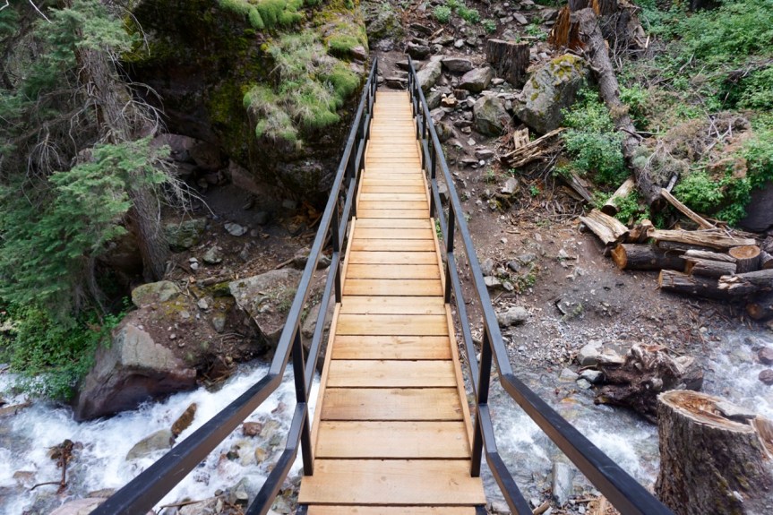
At the end of the narrow ledge was the metal bridge we had been looking for (following directions backwards is difficult!). The bridge ran right over the waterfall. The cool mist was glorious after the steep climb. And under the bridge someone had installed a sculpture of a mountain troll protecting the bridge!


After the bridge the trail continues to climb up but is not nearly as narrow or as steep.


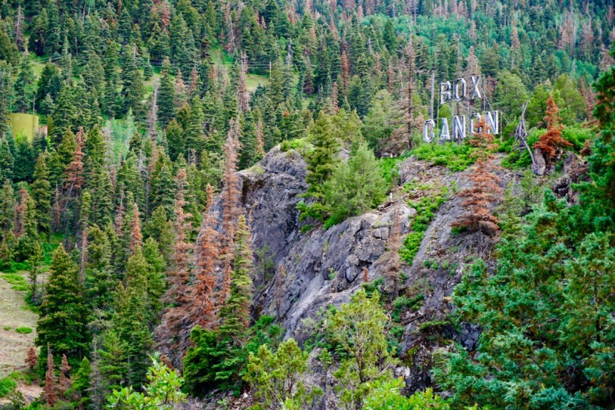
Our end goal was Box Canyon Park, a super powerful waterfall that flows through the mountains. The park has a $4 entry fee to see the lower levels of the falls. As a hiker you can hike through for free if you don’t go onto the catwalk to the lower section of the falls.
After the trail gradually made its way down the mountain, we came to a set of super sketchy looking stairs built into the side of the cliff. There was a guard rail and a cable on the other side to hold onto while you pulled yourself up. I really think these were built for going down not up. We saw a trail runner run straight down the stairs like it was a sidewalk while we struggled to drag ourselves to the top. Now, that guy was clearly in better shape than us but I’m gonna give us some credit and insist that it must be easier going down than up.

After the stairs we came to a tunnel carved into the rock. It was dark but short. You could see the light at the other end and hear the roar of the waterfall about to greet you on the other side.
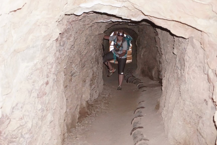
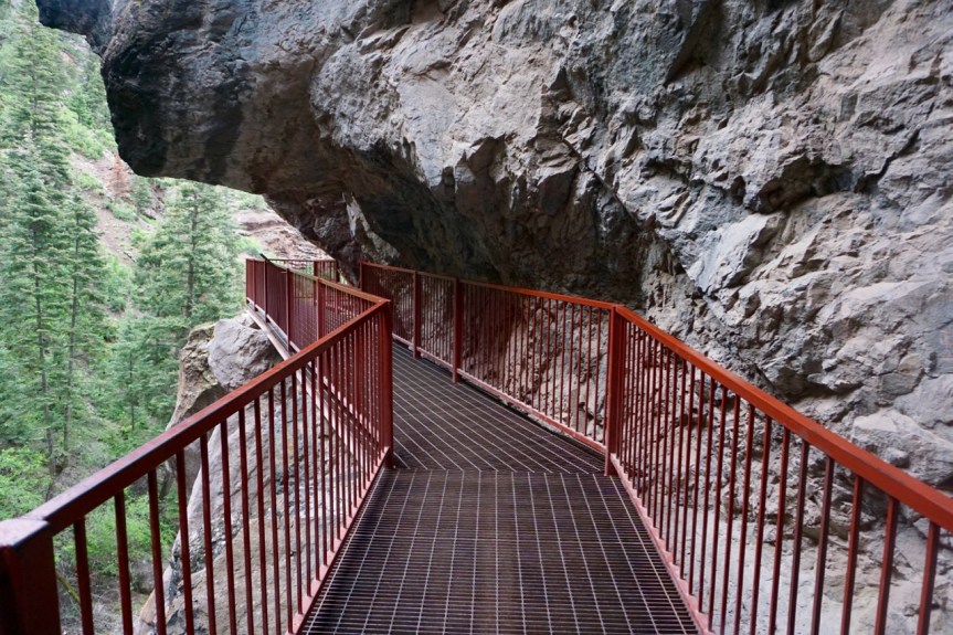
From the opening of the tunnel you walk onto a metal bridge overlooking the waterfall.


This is the section of Box Canyon Falls that is accessible to hikers without a fee. However, I highly recommend paying the $4 per person and going to see the lower falls. But for what it’s worth, no one was paying attention to whether or not you paid. We walked right into the lower section of the falls without running into a single person. But being the overly honest person that I am and wanting to support the protection of places like this, I did stop by the visitors center when we were done to pay the entrance fee.
The man behind the counter was very British.
“We just hiked in from the other direction and walked through your waterfall. Am I supposed to pay here?”
“Well . . . you’re supposed to. How many will it be love?”
He said “love” in the way that men with foreign accents just seem to get away with. It was charming and delightfully British.
I told him “two” and handed over my debit card because we were completely out of cash. Before leaving on our hike I actually counted out our laundry quarters to pay the park fee but only came up with $5.50.
The lower falls are really spectacular. The metal catwalk (which felt very safe, by the way) takes you down the canyon wall and to the bottom of the falls. After a long hike, at least for us, the shade and mist was very refreshing.


If you look closely you can see some old mining equipment that got stuck here back in the 1960s. I also think that the rock face looks like the profile of a Native American man’s face.
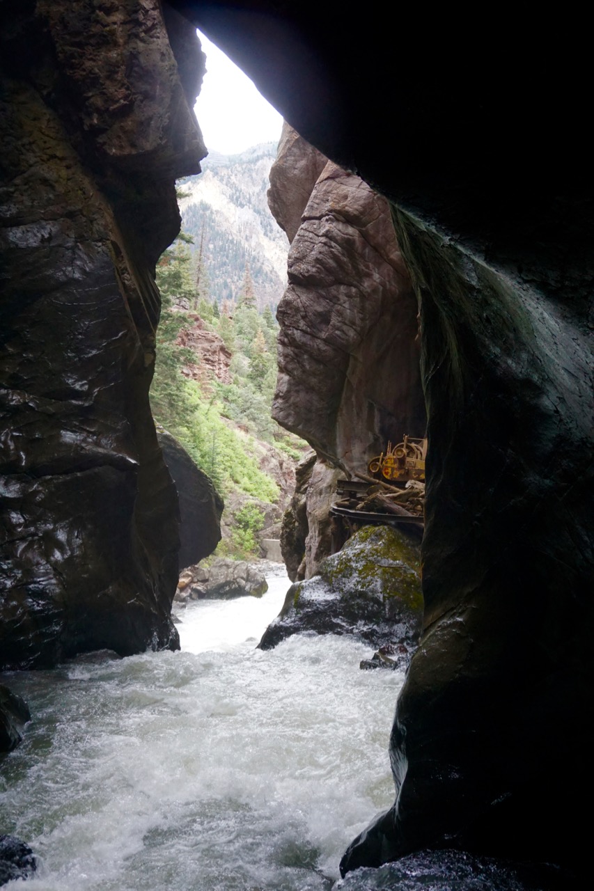
The canyon is also home to the rare black swift bird, who uses the canyon walls for nesting. We didn’t see any unfortunately.
Leaving Box Canyon we crossed over another bridge. From this bridge you can see where the clear snow melt of Canyon Creek (which feeds Box Canyon Falls) meets with the yellow iron-rich water of the Uncompahgne River. The Uncompahgne runs down from the red mountains we drove over the day before. Here you can literally see the two water colors meld together and soften.

We followed the short trail back to town with a plan to have dinner before walking back to our campsite a few blocks away. Although we didn’t walk an exceptionally long distance, the steep ascent made it strenuous and I started to understand what long distance hikers must feel when they finally come across a town. The smell of burgers grilling was intoxicating.
We passed up the fancy Italian place, Bon Tons, in favor of the Outlaw Saloon. The atmosphere seemed more inline with our current state of sweaty grimyness. Brandon ordered the steak with shrimp and I ordered the spinach ravioli with marinara. I had serious order envy when his steak arrived but Brandon was nice and gave me a few bites. Note to self: after hiking, just order the darn steak.
Ouray, you’ve been fabulous, but we’re heading north in the morning. Hope to see you again soon.


A couple of awesome photos! This looks like some people do in the whole vacation.
LikeLike
Looks like a great place. Keep on having fun. Love you both.
LikeLike
Looks like such an epic adventure. Hopefully we can join ya on the next!
LikeLike